Rating of navigation programs for Android without the Internet. Which navigator to install on Android to work without the Internet
Recently, technology has come so far that modern people simply cannot imagine themselves without some kind of gadget at hand.
Here you have smartphones, tablets, and smart watches have already begun to be invented... In a word, mobility and nothing more! And many of us also drive cars. And here DVRs and navigators have become indispensable assistants. So we decided to talk about the best navigator in our opinion - Navitel.
In general, there are many navigators available for the “Green Robot” - both the program from Yandex and Google have their own navigator. So what's so special about Navitel? The fact that it is able to work without connecting your device to the Internet. This “animal” works with GPS networks.
There are different cases: the money in the account may run out, or the mobile network may simply work slowly, and there are devices that do not have 3G. Just for such cases, Navitel is an indispensable thing that will not let you get lost, no matter where you are.
“Where are you? What even in the outback?” - you ask. At least, the author of this review has personally been using this program for three years. And in the Rostov region and Krasnodar region the program works perfectly. You just need to wait a little while the navigator communicates with GPS satellites.
Now we need to talk about Navitel’s convenient and accessible interface. When you start the program, the main menu appears, the items of which speak for themselves. For example, the “Find” tab allows you to search for a destination using the following parameters:
- by the address;
- by search history;
- by favorite points;
- by network coordinates;
- on the map.
The “Route” tab will help you create the shortest path to the point. Here you can find the same items as in the “Find” tab, and set a route to any building, office, or simply to an address.

Well, the last menu is “Settings”. It deserves special praise and flattering words. This is where we can see the most striking example of personalization. Navitel can be configured exactly the way you need. There is map scalability, night mode, and a 3D map. It is possible to configure the navigator so that it builds routes, avoiding dirt roads or ferry crossings. Literally everything is customizable, which is very pleasing!


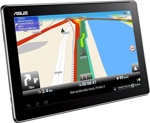
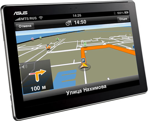
We can’t help but talk about the most important part of the navigator – the map, which is displayed while moving. In general, you can judge it based on my screenshots - everything is clearly visible there. I will just note that Navitel provides comprehensive information about the route: when the next turn is visible, and how long is left to go to the destination, and traffic jams can be seen where they are (by the way, you can bypass them - Navitel settings).


What was also pleasing was the fact that this program provides information not only about the place of arrival, but also about a specific object located at the address. When we click on each building we can see a list of organizations that are based there.


All the words of praise that are written above are only part of all the good things that are in Navitel for Android. The application is very easy to use, provides comprehensive information and does not freeze. A solid “Five” and many thanks to the developers!
Probably every smartphone user had to turn to a navigator for help. There are times when you are in a foreign city and don’t know how to get to a certain place. Some people ask passers-by in the old fashioned way, but there are not always people willing to answer you. If you have a smartphone, then it is best to turn to your navigator for help. Almost all young people know how to use a navigator on their phone. But older people most likely don’t even know that such an application exists. In this article we will talk about how to use a navigator on your phone, as well as how to handle it in the forest and without the Internet.
Using the navigator
Let's look at the instructions for using the navigator:
- First of all, you need to make sure that your phone model supports the navigation function. If your phone is an old model that does not have this application, then, alas, you will have to purchase a new one.
- Download the application on the website or in the store, install it, after which you need to launch it. After launch, you will see several options: find an address, follow a route, search for a deposit, etc.
- If you need to find a specific establishment or a specific address, then you need to enter it - and the application will find the way for you.
- If this is your first time using a navigator, then practice with the nearest address and you will see how it works.
- After entering the required address, the device will give you voice alerts about where you are going and where you need to turn.
- All you need to do is pay attention, because if you take a wrong turn, the device can change the trajectory of the path to the required address.
- You can find a shortcut to the desired location yourself. You can also choose a voice that will notify you.
- If you need to get to a restaurant or store, then you need to select a location search, the navigator will find you all the suitable places.
Using a navigator without the Internet

A huge disadvantage of all navigators is that they only work via the Internet. And, as you know, mobile Internet is quite expensive, and not everyone can afford to connect to it. The Internet consumes your data limit and also drains your battery. This happens due to a constant connection to the Internet. Many users ask the question: how to use a navigator on a phone without the Internet? The answer is quite simple. Now there are many applications that work without an Internet connection. You can also download a map of any city you need and use it without connecting to the Internet. You can view directions using the saved map. How to use a navigator on your phone? This is much easier with downloaded maps if you do not have access to the Internet.
Navigators that work without the Internet
With such applications, you will no longer have the question of how to use the navigator on your phone. Let's look at the most popular applications that do not require an Internet connection:
- SygicAuraMaps.
- MapDroid.
- MaverickPro.
- NavfreeFree GPS.
Navigator and forest

Before you get ready to go into the forest, you need to study all the settlements, roads and railway tracks that are nearby. You also need to take a map and compass with you. If you don’t have this or that item, it doesn’t matter, you can use your phone. You just need to download the navigator and compass. on your phone in the forest? Very simple, just like in the city. Once you enter the forest, save your location. And that’s it, you can walk through the forest as much as you want. You can even turn off your phone so as not to drain the battery. Once turned on, it will show where you are and where the starting point was. So don't worry about getting lost, walk and enjoy the fresh air.
Many car enthusiasts now use navigators. Such devices are especially in demand on long trips, in unfamiliar cities or places. Currently, stores offer a wide range of GPS navigators, but most of them do not meet the requirements that are important for normal navigation in a car. Is it really necessary to purchase a navigator? Can a device running Android OS be used in this capacity?
So, let’s assume that you have a tablet or smartphone, because now rarely anyone can do without them. And if the gadget has a GPS module, then you have an excellent navigator in your hands. In most cases, it will work much better and more reliably than GPS routers on the market.
Navigator for Android is a special application that can perform address searches and plot the most optimal route, taking into account the type of transport, traffic jams and road repairs.
Today on Google Play you can find a huge number of free navigators for your Android smartphone or tablet. But which one is better to choose? We tried to make your search easier and collected the ten most popular navigators.
Pros of a navigator on Android
List of main advantages:
- Operation speed- most Android devices have powerful processors, so their speed will be an order of magnitude higher than that of navigators.
- Functionality- the functionality of a tablet and smartphone is much wider. With their help, you can not only visually monitor the map of the area, but also receive information about traffic jams, talk on Skype, and use other Internet features.
- Battery power- the presence of a capacious battery allows the gadget to work autonomously for 6 hours or more. But the navigator battery will, at best, last you 30 minutes of operation.
- Big screen- it is much more convenient to watch the map on it than on the screen of a miniature navigator.
- Software Update- Navigators are often equipped with firmware, which is very problematic to replace with more recent ones. On Android there is no navigation firmware at all. She simply isn't needed there. All you have to do is download the APK, run the installer, and you’re good to go. If you wish, you can update the map version in a couple of minutes and load other maps.
Disadvantages of a navigator on Android
Are there any downsides to using your phone as a car GPS navigator? There are, and we will list them now:
- Screen size- a large screen, it turns out, can be both a plus and a minus. The fact is that if the tablet is large, then it is problematic to place it on the front panel. This requires special fastenings. If you just put the tablet on the next seat, it will be inconvenient to use.
- Price- the cost of a tablet is higher than the cost of an average navigator. And buying a cheap phone is risky. It may have a weak processor and no GPS module. However, there is a way out here too. You can purchase a tablet and an external GPS module separately. In terms of its parameters, such a module is superior to its built-in analogues. True, the external module drains the tablet's battery, but it can always be recharged from a car battery.
- GPS module- tablets produced by not very well-known companies have weak GPS modules that are inferior in sensitivity to navigator modules. The exception is devices manufactured by well-known companies. Everything is fine with their modules, the quality of the equipment is excellent.
Installing a navigation program on Android is not difficult. You can download it from Google Play, and then just run it as a regular application. A new icon will appear on the gadget's desktop.
The best navigators for Android
 1. Yandex Navigator– An excellent application that will show you how to get to your destination without traffic jams so that the journey takes less time.
The navigator calculates how best to get from the start to the destination, taking into account traffic jams and road events - accidents and other accidents, repairs and road closures. There are up to three travel options to choose from, starting with the fastest. If the route passes through a toll section, the application will warn you about this.
DOWNLOAD YANDEX NAVIGATOR

 2. Navigator– the second most popular application, with more than 5 million downloads worldwide. The application will help all users quickly open and use popular maps with GPS navigation. Open navigation on your phone in one click.
The size of the program is only 4.6 M and it is available for free download on Google Play.
DOWNLOAD FROM GOOGLE PLAY
is a free detailed GPS navigation app that uses OpenStreetMap data. The application works on most Android smartphones and tablets. Maps are installed on the device's internal memory or SD memory card in advance, so that there is no need to connect to the Internet while traveling. Maps and the application are updated once a month completely free of charge.
DOWNLOAD MAPFACTOR

 4. Navitel GPS & Maps– accurate offline GPS navigation, geosocial services and detailed maps of more than 60 countries. The application has already been installed by more than 20 million people around the world.
Among the advantages it is worth noting:
- GPS/GLONASS.
- Offline maps support.
- Information about traffic jams.
- 3D cartography of interchanges.
- Multilingual voice prompts.
DOWNLOAD NAVITEL

 5. 2GIS: companies, map and navigator– a popular reference book with a map and navigator. The application works without the Internet - download the city database and use it on the plane, metro or roaming.
Features and benefits:
- Convenient navigation.
- Database of cities in Russia, Ukraine, Kazakhstan and other CIS countries, as well as Cyprus, Czech Republic, Chile and the UAE.
- Shopping center plans. Shows everything: from shops and cafes to ATMs and toilets.
- Data about services, addresses, opening hours and companies.
DOWNLOAD 2GIS

 6. Navigator Seven Roads– Another good navigation program called “Seven Roads”. The application supports offline openstreetmaps (OSM maps) and is capable of plotting routes longer than 10,000 km. You can always easily customize your navigator as you wish. Add-ons are ready to be downloaded from the program at any time.
Main features:
- GPS and Glonass (GLONASS).
- Offline maps support.
- Ability to create your own cards.
- HUD mode.
- Huge selection of additional extensions (maps, skins, languages, voices, translations, etc.)
DOWNLOAD 7 ROADS
 7. Waze is a large navigation application that is supported on a public basis. You can also join the Russian driver community and share information about traffic situations and save time and money on your daily trips.
Simply by traveling with the Waze app, you help keep road and traffic information up to date. You can also send reports about accidents, dangers, police and other events, as well as receive this information from others, including prices at gas stations. In addition, you can add friends, share your arrival time and trip.
DOWNLOAD WAZE
 8. Navigator with traffic jams bGEO– a good hybrid GPS navigator with traffic jams, working without the Internet. BGEO combines all the advantages of offline navigation and online applications. The navigator uses compact City Guide and OSM maps for its work.
BGEO works in poor connection conditions because all downloaded maps are automatically cached on your device. If there is no access to the Internet, the program automatically switches to offline mode and starts working as a standalone GPS navigator.
In this day and age, it’s hard to get around in a city without a map. This is especially true for motorists who travel long distances, travel by car between cities and often travel to unfamiliar areas. An assistant in finding a way - a navigator. This is an application that is installed on the phone and builds a route along which it guides the traveler. In this article we will talk about which navigator to install on Android.
The advantage of using a navigator on your phone
Previously, navigators were only separate devices that needed to be purchased and selected separately. This entailed extra expenses and the need to understand the technical side of the gadget. There is a danger of making a mistake and choosing a bad device, there is a danger of breakdown.
They are preferred because they:
- Free. And if you want to buy a paid application, the amount is not large.
- If you don't like the program, uninstall it and install a new one.
- Does not require a separate device.
- Performs all functions of road navigators.
- Can work without the Internet.
The benefits are obvious.
Android navigators for cars
But which navigator is better to install on Android? There are dozens of items in the app store. There are paid and free ones, working with or without the Internet, with voice assistants, maps for individual countries and cities. With a different interface, those where you can watch traffic jams and traffic police posts. We selected the TOP similar applications in the Play Market and compared them:
| Navigator without Internet on Android | |||
| Navigator | Offline mode | For free | Voice control |
| Google Maps | Yes | Yes | Yes |
| Yandex Navigation | There are maps, no routes | Yes | Yes |
| Navitel | Yes | No | No |
| Yes | Yes | No | |
| MapFactor | Offline only | Yes | No |
| Waze | Across Russia | Yes | Yes |
| Yes | Yes | No | |
| 7 roads | Yes | Yes | No |
| OsmAnd | Yes | No | No |
| Sygic GPS Navigation & Maps | Yes | Yes | No |
And now more details about each of the applications.
Google Maps
Google MapsThe Internet corporation specializes not only in Internet searches. In Google Maps you can get directions using different types of transport. Google Maps is available on all modern phones that run Android. If you don’t really like choosing and downloading applications, the question of how to install a navigator on Android will not arise.
There is online and offline mode. When connected to the Internet, you can build any route, even on public transport. And offline there is only a road route, if the map is downloaded to the phone’s memory in advance. It downloads in the application.
Google Maps has maps for almost the whole world. Wherever you go, the path is always with you. There is a voice assistant and the ability to view the area in 3D format.
Yandex Navigator

 Navigator Yandex
 Navigator from Yandex is one of the leaders in the Russian segment of the Internet. For Russia, this particular application provides the most accurate routes. Takes into account traffic jams, accidents, repairs and even toll roads. Yandex navigator is easy to install on Android - you just need to download it for free in a couple of minutes.
Sometimes you are unable to download an app due to the common df-dla-15 error in Play Market. We how to deal with it.
Builds routes taking into account all the information about the road. Convenient thanks to voice control. You need to say: “Listen, Yandex!” He will plot the route by listening to the voice directions. This minimizes emergency situations on the road - you don’t need to be distracted to set up Yandex Navigation. The question of how to update Yandex navigator on Android has a simple answer: connect your phone to the Internet, go to the Play Market, select the “Updates” tab and click “Update” under the application icon. The whole process takes no longer than five minutes and the relevant information is already in your smartphone.
One of the disadvantages is that you cannot pave the way without connecting to the network. If you are good with a map, you can get there by looking at the image of the area.
Navitel
 Native
 Navitel is often used by taxi drivers and delivery drivers, since without the Internet it works perfectly anywhere. But it's paid. After installation there is a week of free trial period. You can use maps of 64 countries. After 7 days you will have to buy maps of countries and cities. For taxi drivers driving in one city - it’s not expensive, but a truck driver will go broke on the application - buying a map of the whole country is expensive!
The SpeedCam function notifies you about speed bumps, traffic cameras, radars, and traffic police posts.
 Navigator 2GIS
 A very popular navigator that works without the Internet on Android. There is also an online mode. 2GIS has an extensive database of enterprises. In shopping centers, shops and cafes are marked on a detailed map of each floor. The database is up-to-date, since moderators often call the enterprise or establishment and clarify the information.
The downside is that many small settlements are not on the maps, so it is not suitable for residents of villages or towns.
MapFactor
 MapFactor
 This is a free navigator for an Android smartphone without the Internet; it uses OpenStreetMap to work. Updates occur once a month. But there will be no information about traffic jams and accidents. Information about cameras installed along the route is also updated only once every 30 days.
Controls if the driver is speeding. Will build routes for cars and pedestrians.
Waze
 Waze
Waze In Russia it can work without the Internet as a simple navigator, but the data will not be updated and you will not know about traffic jams, traffic police ambushes or accidents. If you stand still for a long time, the application will close itself so as not to drain the battery on your phone. Automatically changes the route if information is received that there is an accident, traffic jam or other unpleasant disaster along the route. But the function only works with the Internet.
Of the minuses, it uses up charging quickly, and the navigator also lacks numbering for some houses.
7 roads

 7 roads
 A navigator program for Android that works without the Internet and uses OpenStreetMap. Available for free. The interface is similar to Windows 8 or 10.
If there is music playing on your phone, the program will turn it down to give voice guidance when needed. Then everything will come back. Disadvantage: You can't monitor accidents or traffic jams.
If you often move between cities, this GPS navigator for Android without the Internet will not suit you. In the application, maps of cities are installed separately, despite the fact that there is a general map of Russia. Therefore, if a route is built from one city to another, there will be small errors along the way. And when traveling, even a small mistake can turn out to be significant.

Maps are updated almost daily to ensure that the application works effectively without an Internet connection. Each person can add information about the objects that have appeared in the city. After the edits, specialists check their accuracy and update the maps.
It works perfectly in offline mode, the terrain detail is at a high level. But maps take up a lot of memory on the phone, and the weight of the application is constantly increasing due to updates.
Another disadvantage is that since the application works without the Internet, there will be no information about traffic jams, accidents and what is happening on the road.

Developers: TomTom. This is an indicator of the accuracy of the image of terrain and roads. Almost all maps that are available also have a 3D view.
The application is paid, but the main functions are also available in the free version. The voice assistant differs from the assistant in analogues: it not only notifies you before turns, but also tells you if you are passing a landmark or along a historical street.
The maps contain information about cameras, traffic jams and road posts. Additionally, there are notes about parking spaces and parking prices, there is information about gas stations, hotels, shopping centers, cafes along the road, and so on.
You can keep in touch with friends through the application, but the function is only available when connected to the Internet. You can connect via BlueTooth to your car radio if the sound on your phone is bad.
OsmAnd
 Navigator Osmand
 Also a great choice if you need a GPS navigator for Android. The application is paid. It works without the Internet and shows all the necessary maps and routes offline. It can work with OpenStreetMap, Yandex and Google maps, as well as others that are installed on your smartphone by default or by choice.
The maps show attractions and useful places: cafes, gas stations, shopping centers, theaters, and so on.
It builds paths well in mountainous areas. But there are only 2D maps.
Please note that viruses can interfere with the normal operation of your smartphone. We recommend that you read it if you want to extend the life of your smartphone.
Conclusion
We have described only part of the programs that you can download for free from the Play Market. But the question of which navigator is better for Android is subjective. For some, it is important to work without the Internet, for others, 3D maps are needed. Determine your priorities in functionality and use them when choosing an application. How much can you pay or don’t want to pay?
Look at the “weight” of the application to see if there is enough space on the phone for it. This market is constantly evolving and soon there will be better options if you are not completely satisfied with any of the existing ones.
Good afternoon, dear readers! It's the 21st century, smoothly flowing into the 22nd, just the time when technology literally saves. Gone are the days when navigators were installed in cars as a separate device. Now almost everyone has an Android smartphone, on which you can safely install any of the proposed navigators from the Play Market. If you ride in a taxi, pay attention to what the drivers use to take you to your destination. Precisely a smartphone. Navigators for Android smartphones are gaining popularity every day.
Let's try in today's article to determine the best navigator for Android in 2019. They all have their pros and cons. What functions should a really good navigator have, in your opinion? Answer the question and move on...
In addition to specialized navigators for Android, the review also includes digital maps, the functionality of which includes a navigator. You shouldn’t write them off, because they are very good. And plus, if you have certain cards installed, then you will not have to install any additional programs. You are ready to travel!
How to choose a good navigator for your car?
What qualities a good navigator should have depends, first of all, on your preferences. After all, some people need the navigator to work offline, while others, on the contrary, see an advantage for themselves in online navigators. Some people are looking for software that is cheaper or even free, while others, on the contrary, are willing to pay for good service. The third person will give preference to pleasant 3D graphics to the detriment of the accuracy of the maps. And so on, do you understand what I'm getting at?
What is the advantage of using an Android navigator?
Judge for yourself, before, when buying a navigator, you would also have to pay attention to the technical characteristics of the device. And if you made the wrong choice, you would have to change the product. Or sell it as used and buy a new one, better quality and more suitable for you personally.
With Android navigators everything is much simpler. If you don't like the navigator, you delete it and install another one. And the power of modern Android smartphones is now quite enough to cope with the most resource-demanding navigators.
Comparative table of navigators for Android phones 2018-2019.
| Offline mode | For free | Traffic jams | Voice assistant | Voice control | 3D maps | |
| Google Maps | There is | Yes | shows | There is | There is | + |
| Yandex Navigator | maps, no routes | Yes | shows | There is | There is | + |
| Navitel | There is | No | shows | There is | No | + |
| 2 GIS | There is | Yes | Not in all cities | There is | No | + |
| MapFactor | yes (no online mode at all) | Yes | No | There is | No | + |
| Waze | available in Russia | Yes | shows | There is | There is | + |
| 7 roads | There is | Yes | No | There is | No | + |
| HERE Maps | There is | Yes | shows | There is | No | + |
| MAPS.ME | There is | Yes | No | There is | No | + |
| ROUTE 66 | There is | Yes | There is | + | ||
| OsmAnd | There is | No | only when working with Yandex maps | There is | No | — |
| CoPilot GPS | There is | +/- | shows | In paid version | In paid version | |
| Navigon | There is | No | shows | + | ||
| Sygic GPS | There is | +/- | yes, even offline (statistics and forecast) | There is | No | + |
Voting for the best navigator for Android
The rest of the article presents the most popular navigators for Android devices with a brief description of each. If you have already worked with any of them, you can leave a review. In the meantime, I suggest experienced drivers, racers and aces hold a small vote for the best and most convenient navigator. You can select several options, but no more than 3.
Google Maps

Google Maps navigator
The giant corporation Google, of course, primarily specializes in Internet search, but this does not prevent it from creating excellent products in other areas. A striking example of such a product is Google Maps with GPS navigation and the ability to plot routes for different types of transport. Need I say that Google Maps is one of the best navigation systems on Android?
It is noteworthy that Google Maps is installed by default in almost all modern smartphones based on the Android OS.
Can work both with the Internet and without the Internet. Viewed maps and territories are simply cached in your phone's memory and can then be used if you do not have mobile Internet and there are no WI-FI points nearby. But it's important that The caching function can be disabled if you don't need it.
Google Maps contains maps of almost all countries of the world (including maps for Russia), which, of course, is a significant plus for those who like to travel. Wherever you go, you will be able to navigate the area, and you will not have to additionally install any local navigators.
Yandex Navigator

Yandex Navigator
Yandex, as you know, is also a search giant and occupies a leading position in the Russian Internet. Many Russians believe that Yandex Navigator is the best navigator for Android in Russia, given its capabilities.
Considering the origin of the development, it is not surprising that Yandex navigator lays out the most accurate routes across Russia. Moreover, he lays out routes, taking into account traffic jams, road repairs, accidents and toll roads. Surprisingly smart navigator, isn't it?
Yandex Navigator has one more feature - voice control. To activate, you just need to say “Listen, Yandex!” and ask for directions to the desired point. For drivers, this is just a fairy tale, given that their hands are almost always full.
On the map you can see useful places to eat, where to refuel, local attractions and more.
Unfortunately, there is also a drawback. Without the Internet, you will not be able to get directions. But the map will remain available to you, so you can somehow get to the right place.
Navitel

Navigator Navitel
Navitel is one of the first and best navigators that works without the Internet. Managed to establish itself among regular users (for example, taxi drivers). However, this is a paid navigator. After installation, you receive a free trial period of 7 days, during which all cities in all 64 countries with which Navitel works are available for you to navigate. After the trial week expires, you will have to buy maps of cities or countries. Therefore, the Navitel navigator is better suited for those people who need navigation within one city, it’s cheaper.
You should also not forget that although Navitel is the best navigator without the Internet, you can only find out the state of traffic jams and weather conditions along the route if you have an Internet connection. After all, you can’t live without the Internet now! Also, without the Internet, you will not be able to update to the latest maps, and believe me, they can change over time.
The SpeedCam feature will alert you to nearby radars, highway patrol posts, speed bumps and road cameras. Well, how do you like the bonus? Navitel rightfully deserves the title of the best navigator for Android without the Internet. If only it were free...
Navigator 2GIS

2GIS navigator
This navigator is most popular among users of Apple products, although it is also rapidly gaining popularity on Android phones.
Offline navigation is available. 2GIS also boasts a huge database of enterprises marked on maps. Large shopping centers have a detailed plan of each floor with the names of stores and other establishments.
The information base of enterprises is constantly up-to-date, because they call enterprises periodically and ask if anything has changed. I personally witnessed this, so these are not rumors!
If you are from a small town or village, then there is a chance that you will not find your locality on 2GIS maps.
MapFactor
This free navigator for Android works offline with OpenStreetMap maps. Maps are updated every month. However, due to its offline nature, you will not see any information about traffic jams or road accidents on the maps. But information about cameras on the roads is available and updated every month.
Has an overspeed control function.
Can work in car mode and pedestrian mode.
Waze - social navigator in Russia

Waze may be a unique navigator, and here's why. Essentially, Waze is a social network for motorists that is used by millions of people. There is integration with Facebook for easy login and communication with friends.
All information about traffic jams, road conditions, gasoline prices at certain gas stations is added by users like you. And you, too, can share useful information with everyone, while earning points and improving your motorist rating. It easily functions without the Internet in Russia, however, as you understand, the relevance of the data will suffer.
If you stand still for a long time, the navigator will automatically close. This is done to save your battery, which Waze drains very quickly during active use. Another drawback is that many houses are not numbered.
But an undeniable advantage is that Waze can automatically rebuild the route depending on changing traffic situations. But this only works online.
7 roads

Another free navigator for Android, working with OpenStreetMap and without the Internet. You will most likely enjoy the convenient and intuitive tiled interface (like in Windows 8/10).
A significant drawback of “7 roads” is the inability to track traffic jams and current conditions on the roads, for example, accidents. However, developers are working to solve this problem.
Another minor drawback is that city maps work as if independently of each other. Although there is a general map of the country (for example, navigation in Russia), when building routes from one city to another, small errors are possible, which are automatically corrected when crossing the boundaries of city maps.
HERE Maps

There was a time when this navigator only worked with Nokia smartphones. But, fortunately, it was able to develop and now HERE Maps is available for all Android devices and can please you with free navigation throughout Russia and without the Internet. By the way, HERE Maps works not only with Russian maps, but with 100+ countries around the world.
Useful places and establishments such as restaurants, cafes, etc. are marked on the maps. Some shopping centers have a detailed plan of each floor, like 2GIS.
When using HERE Maps, you can use other smartphone applications, and the voice assistant in the background will always promptly inform you about upcoming turns and other important information.
It is also possible to share your location with friends, as well as track their location on maps.
To work without the Internet, you need to download maps to your phone in advance. In this case, all functionality will work fully.
MAPS.ME – offline maps

It is not surprising that this application is included in the world top of the best navigators for Android. The maps of this navigator are updated almost every day. Anyone can enter information about new objects that have appeared in the city, for example, public gardens, parks, fountains, buildings, etc. After this, the information is verified and the maps are updated. Thanks to this, the number of additional alternative routes and the ability to choose the shortest one are constantly increasing.
A distinctive feature of the MAPS.ME android navigator is its good offline operation with highly detailed terrain. But this is also its disadvantage - cards take up a lot of memory in your Android device. You have to pay for the service, in this case in memory.
Here's a fly in the ointment. There is no information about traffic jams.
ROUTE 66 Navigate

ROUTE 66 Navigate
Unlike other navigators for Android, ROUTE 66 uses TomTom maps, which are highly accurate and are most often installed in premium cars from the world's leading auto manufacturers.

ROUTE 66 - Follow Me
Another significant feature of the ROUTE 66 Navigate is their signature “Follow Me” feature. Follow Me is powered by augmented reality and can display the route your companion has taken in real time. This feature will be very useful if you were driving behind a partner and for some reason fell behind him and lost sight of him.
Navizor – quality of roads

A promising Russian development designed to help motorists save their cars from bad Russian roads. This is a very relevant application for Russia, and it would be wrong not to mention it.
The essence of Navizor is that users leave ratings for the roads they drive along. And all this is marked on the maps. When planning a route, Navizor takes into account the condition of the roads and will take you further away from trouble.
If you haven’t laid out any route, then just approaching roads of poor quality, you will hear a warning sound as if hinting that it is better not to go there if you value your suspension and wheels.
OsmAnd

OsmAnd is perhaps the best navigator for Android without the Internet. Its distinctive feature is its very good work with offline maps. At the same time, it can work with both OpenStreetMap and Yandex and Google maps and many other popular maps.
The maps show attractions and simply useful places, such as restaurants, cafes, cinemas and more.
It copes well with routing in mountainous areas, which is also an advantage for tourists and travelers.
Alas, OsmAnd is one of the few modern navigators that only works with 2D maps.
CoPilot GPS

CoPilot GPS does not need internet to work. He only uses the Internet for updates about once a month.
There is a walk mode, during which all small pedestrian paths and buildings are indicated on the map. Wikipedia is built into the application.
CoPilot GPS also has integration with popular social networks, so you can share your location with friends and acquaintances.
When planning a route, he will always offer you a choice of 3 possible routes.
Navigon
Navigon can also be considered one of the best navigators for Android without the Internet, given its history and prestige. The fact is that this application was developed by Garmin, a company that was one of the first to develop physical GPS navigators in its time. Now, with rapidly progressing digital technologies, the company decided to keep up and released its application for Android smartphones.
Considering the company’s experience, it is not at all surprising that the application turned out to be excellent and copes with laying routes in offline mode almost flawlessly.
Its main drawback is, perhaps, that the program is paid. But, judging by user reviews, it pays for its price, because it contains all the most useful functions for drivers, for example, information about traffic cameras, speeding in certain areas, and more.
Through the program you can also communicate with friends and exchange your coordinates.
Sygic GPS Navigation & Maps

Sygic GPS Navigation
Definitely one of the best navigators for Android. Sygic GPS Navigation has a number of advantages, which would be better listed in a list for better understanding.
- They were developed by TomTom itself. This means the maps will be very accurate.
- Almost all maps are presented in 3D graphics.
- Basic functions work even in the free version.
- Voice guidance differs from others in that it provides information not only about turns, but also about the streets you are driving through, attractions, and so on.
- The maps display information about cameras, traffic jams and road posts.
- The maps also show parking (available spaces and prices), hotels, shopping centers, gas stations, etc....
- Connect with friends (online only).
- Can be integrated via BlueTooth with a car radio.
It’s a solid list of advantages of this navigator, isn’t it? Here is another contender in the category “The best navigator for Android without the Internet” in Russia and beyond.
Conclusion:
This article does not describe all the navigators available in the Play Market. Obviously, making the right choice is quite difficult. But you can set some priorities for yourself and be guided by them when making your choice.
Soon you will be able to personally vote for the best navigator for Android in Russia without the Internet in 2019, so that the choice is more objective. Plus, if you notice any inaccuracies in the article, point them out and support your colleagues with up-to-date information.
Did you read to the very end?
Was this article helpful?
Not really
What exactly did you not like? Was the article incomplete or false?
Write in comments and we promise to improve!


